
Level 4 Autonomy with Edge AI and Machine Learning
Starting at
$1,900
Powered by
Level 4 Autonomy with Edge AI and Machine Learning
Starting at
$1,900
Powered by
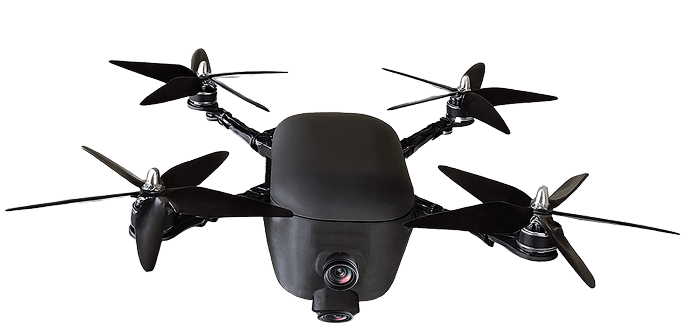
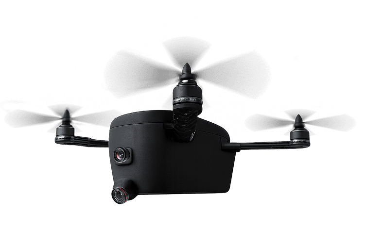
The Blip Badger by Blip Drones is a fast, intelligent, and field-ready UAV engineered for First Responders, Construction, Defense, and Inspection industries. With a 95 MPH top speed, 15-minute rapid charging, AI-driven autonomy, and dual 4G/5G connectivity, it delivers mission-critical performance where speed and precision matter most.
Type:
Quadcopter UAV
Weight:
4.5 lbs (2.04 kg) including battery
Frame Material:
Carbon fiber composite
Propulsion:
4 high-efficiency brushless motors
Battery:
8,000 mAh 22 V LiPo battery
Flight Time:
~25–35 minutes
Payload Capacity:
Up to 1.0 lb (0.45 kg)
Top Speed:
95 MPH (153 km/h)
Charging Time:
15 minutes (rapid-charge system)
Quadcopter UAV
4.5 lbs (2.04 kg) including battery
Carbon fiber composite
4 high-efficiency brushless motors
8,000 mAh 22 V LiPo battery
~25–35 minutes
Up to 1.0 lb (0.45 kg)
95 MPH (153 km/h)
15 minutes (rapid-charge system)
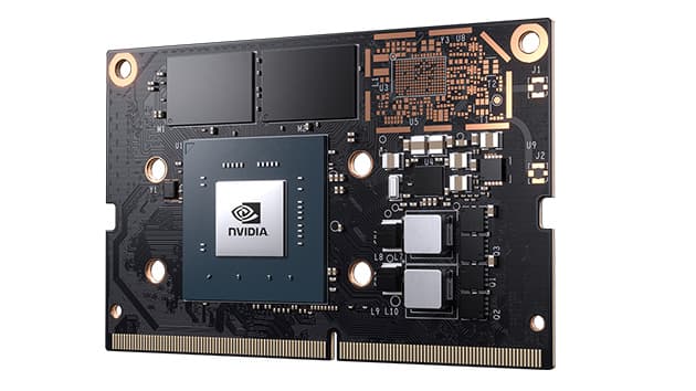
Onboard Computer:
NVIDIA Jetson (Nano / Xavier / Orin variant)
AI/ML Frameworks:
TensorFlow, PyTorch, ONNX
Computer Vision:
YOLOv8 Object Detection
Autonomous Navigation:
SLAM (Simultaneous Localization and Mapping)
Perception & Path Planning:
AI-assisted obstacle avoidance and adaptive route optimization
Edge Processing:
Real-time inference and analytics onboard
NVIDIA Jetson (Nano / Xavier / Orin variant)
TensorFlow, PyTorch, ONNX
YOLOv8 Object Detection
SLAM (Simultaneous Localization and Mapping)
AI-assisted obstacle avoidance and adaptive route optimization
Real-time inference and analytics onboard
Flight Controller:
CubePilot (Cube Orange / Cube Red)
Firmware:
ArduPilot / PX4 compatible
Navigation Systems:
GNSS + RTK (Real-Time Kinematics)
Positioning Accuracy:
±1 cm (with RTK base station)
Failsafe Systems:
Redundant IMU, barometer, GPS failover, emergency RTL
Flight Modes:
Manual / Stabilize / Guided / Auto / AI Autonomous
CubePilot (Cube Orange / Cube Red)
ArduPilot / PX4 compatible
GNSS + RTK (Real-Time Kinematics)
±1 cm (with RTK base station)
Redundant IMU, barometer, GPS failover, emergency RTL
Manual / Stabilize / Guided / Auto / AI Autonomous
4G LTE:
Integrated telemetry and data uplink for live control
5G:
Ultra-low-latency broadband for HD video streaming and remote operations
Wi-Fi / Ethernet:
Local configuration, firmware updates, and diagnostics
Telemetry Range:
Up to 10–15 km (depending on network conditions)
Integrated telemetry and data uplink for live control
Ultra-low-latency broadband for HD video streaming and remote operations
Local configuration, firmware updates, and diagnostics
Up to 10–15 km (depending on network conditions)
IMU:
Triple redundant high-precision IMUs
Barometer:
Digital altitude sensor
GPS:
GNSS with RTK correction
Vision System:
Dual cameras (front + downward for SLAM and mapping)
AI Camera:
YOLO-integrated 4K RGB sensor
Optional Add-ons:
LIDAR, Thermal, Multispectral payloads
Triple redundant high-precision IMUs
Digital altitude sensor
GNSS with RTK correction
Dual cameras (front + downward for SLAM and mapping)
YOLO-integrated 4K RGB sensor
LIDAR, Thermal, Multispectral payloads
Operating System:
Ubuntu 20.04 / NVIDIA JetPack SDK
AI/ML Frameworks:
CUDA, cuDNN, TensorRT, ROS2 integration
Autonomy:
SLAM-based navigation with AI-assisted obstacle detection
Cloud Integration:
Real-time telemetry via LTE/5G gateways to AWS or GCP
Edge Inference:
YOLOv8 detection and SLAM mapping processed on-device
Ubuntu 20.04 / NVIDIA JetPack SDK
CUDA, cuDNN, TensorRT, ROS2 integration
SLAM-based navigation with AI-assisted obstacle detection
Real-time telemetry via LTE/5G gateways to AWS or GCP
YOLOv8 detection and SLAM mapping processed on-device
First Responders:
Rapid deployment for search & rescue or disaster response Thermal and RGB streaming for situational assessment GPS-accurate mapping and hazard visualization
Construction Monitoring:
Aerial site mapping and time-lapse monitoring AI-powered volumetric and structural inspections Integration with BIM and CAD systems
Defense & Security:
High-speed tactical reconnaissance (95 MPH) Encrypted data transmission over 4G/5G networks Real-time object recognition and patrol automation
Industrial & Infrastructure Inspections:
Autonomous 3D mapping via SLAM and RTK Asset condition monitoring (bridges, towers, pipelines) Optional LIDAR and thermal payloads for critical inspection
Rapid deployment for search & rescue or disaster response Thermal and RGB streaming for situational assessment GPS-accurate mapping and hazard visualization
Aerial site mapping and time-lapse monitoring AI-powered volumetric and structural inspections Integration with BIM and CAD systems
High-speed tactical reconnaissance (95 MPH) Encrypted data transmission over 4G/5G networks Real-time object recognition and patrol automation
Autonomous 3D mapping via SLAM and RTK Asset condition monitoring (bridges, towers, pipelines) Optional LIDAR and thermal payloads for critical inspection